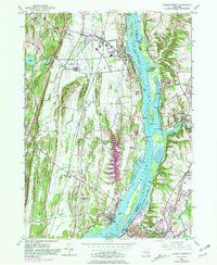
1980 Map of Hudson North
USGS Topo · Published 1981About this map
Hudson River navigation and industrial development define this corridor during the mid-to-late 20th century, particularly where the Hudson city center sits opposite the extensive Middle Ground Flats. The landscape is a complex mix of riverfront settlements like Coxsackie and Newton Hook and institutional footprints, including the Coxsackie Correctional Facility and the Firemens Home. Topographical detail reveals the prominent ridgelines of Flint Mine Hill and Lampman Hill rising above the river valley. The infrastructure of the Conrail line and the Thruway parallels the water, illustrating the region's long-standing role as a primary transportation artery. Historical continuity is visible in the numerous small burial grounds and parish markers such as St Marys Cem and Riverside Cem, while more recent development is noted through purple photorevised updates like the expansion near West Athens.
Find a feature on this map
52 named features on this map. Tap any name to fly to it.
Don’t see what you’re looking for? This feature index may not catch every label — zoom into the map to look around manually.
Map Details
Editions of this 1980 Hudson North Map
This is the sole edition of this map. No revisions or reprints were ever made.
Other maps of this area

1893 · Coxsackie
USGS Topo · 1:62,500

1894 · Coxsackie
USGS Topo · 1:62,500

1895 · Catskill
USGS Topo · 1:62,500

1902 · Copake
USGS Topo · 1:62,500

1903 · Kinderhook
USGS Topo · 1:62,500

1904 · Copake
USGS Topo · 1:62,500

1929 · Coxsackie
USGS Topo · 1:62,500

1933 · Kinderhook
USGS Topo · 1:62,500

1934 · Catskill
USGS Topo · 1:62,500

1938 · Catskill
USGS Topo · 1:62,500