
1929 Map of Coxsackie
USGS Topo · Published 1929About this map
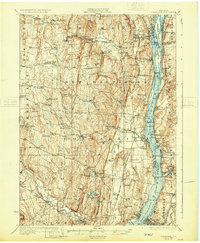
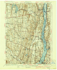
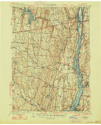
The Hudson River corridor serves as the primary artery for industry and transport in this 1920s survey, defined by the parallel tracks of the West Shore RR and the New York Central RR. The river itself is a complex landscape of shifting channels and islands, including Schodack Island and Houghtaling Island, which supported a network of docks and river landings such as Fitohs Wharf and Schodack Landing. On the western banks, the industrial character of Coxsackie and Ravena contrasts with the numerous numbered rural schoolhouses and small mill sites like Deans Mill that dot the interior hills.
Find a feature on this map
107 named features on this map. Tap any name to fly to it.
Don’t see what you’re looking for? This feature index may not catch every label — zoom into the map to look around manually.
Map Details
Editions of this 1929 Coxsackie Map
4 editions found
Other maps of this area

1892 · Kaaterskill
USGS Topo · 1:62,500

1893 · Kaaterskill
USGS Topo · 1:62,500

1893 · Troy
USGS Topo · 1:62,500

1893 · Coxsackie
USGS Topo · 1:62,500

1893 · Durham
USGS Topo · 1:62,500

1893 · Albany
USGS Topo · 1:62,500

1894 · Coxsackie
USGS Topo · 1:62,500

1894 · Kaaterskill
USGS Topo · 1:62,500

1894 · Durham
USGS Topo · 1:62,500

1895 · Troy
USGS Topo · 1:62,500