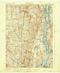
1929 Map of Coxsackie
USGS Topo · Published 1931About this map
The Hudson River corridor defines this 1920s landscape, serving as a primary artery for trade and transportation between Greene, Albany, Rensselaer, and Columbia counties. Along the banks, historic river settlements such as Coxsackie, Stuyvesant, and New Baltimore are shown with their respective landings and stations, including Fitchs Wharf and the Hannaeroix New Baltimore Sta. The map provides an intricate look at the river's complex island system, featuring Houghtaling Island and Schodack Island amidst the Middle Ground Flats.
Find a feature on this map
104 named features on this map. Tap any name to fly to it.
Don’t see what you’re looking for? This feature index may not catch every label — zoom into the map to look around manually.
Map Details
Editions of this 1929 Coxsackie Map
4 editions found


Other maps of this area

1892 · Kaaterskill
USGS Topo · 1:62,500

1893 · Kaaterskill
USGS Topo · 1:62,500

1893 · Troy
USGS Topo · 1:62,500

1893 · Coxsackie
USGS Topo · 1:62,500

1893 · Durham
USGS Topo · 1:62,500

1893 · Albany
USGS Topo · 1:62,500

1894 · Coxsackie
USGS Topo · 1:62,500

1894 · Kaaterskill
USGS Topo · 1:62,500

1894 · Durham
USGS Topo · 1:62,500

1895 · Troy
USGS Topo · 1:62,500