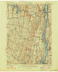
1929 Map of Coxsackie
USGS Topo · Published 1948About this map
The Hudson River corridor serves as the primary artery for commerce and navigation in this 1920s-era survey, where the river's path is dotted with notable riverine features like Bronck Island and Houghtaling Island. Along the eastern shore, the infrastructure of the New York Central and the maritime presence at Fitchs Wharf illustrate the transport-heavy economy of the late 1920s. Inland, the landscape is defined by the massive Alcove Reservoir and numerous small-scale industrial sites such as Deans Mill.
Find a feature on this map
118 named features on this map. Tap any name to fly to it.
Don’t see what you’re looking for? This feature index may not catch every label — zoom into the map to look around manually.
Map Details
Editions of this 1929 Coxsackie Map
4 editions found


Other maps of this area

1892 · Kaaterskill
USGS Topo · 1:62,500

1893 · Kaaterskill
USGS Topo · 1:62,500

1893 · Troy
USGS Topo · 1:62,500

1893 · Coxsackie
USGS Topo · 1:62,500

1893 · Durham
USGS Topo · 1:62,500

1893 · Albany
USGS Topo · 1:62,500

1894 · Coxsackie
USGS Topo · 1:62,500

1894 · Kaaterskill
USGS Topo · 1:62,500

1894 · Durham
USGS Topo · 1:62,500

1895 · Troy
USGS Topo · 1:62,500