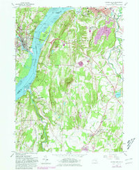
1980 Map of Hudson South
USGS Topo · Published 1981About this map
The Hudson River dominates this landscape, serving as a vital industrial and cultural corridor connecting settlements like Hudson, Catskill, and Germantown. On the eastern bluffs, the Olana Historic Site overlooks the water from Churchs Hill, preserving the estate of Frederic Edwin Church. The riverbanks are marked by heavy transportation and maritime infrastructure, from the Rip Van Winkle Bridge to the Conrail tracks following the shoreline. Numerous maritime landmarks such as Burden Dock and Washburn Dock reflect the river's historical role in commerce. Further inland, the map captures a transition to institutional and agricultural land use, including the State School for Girls and several cemeteries like Livingston Reformed Cem. The presence of several quarries near Becraft Hills and the winding Roeliff Jansen Kill further define the geography of the Columbia and Greene county borderlands.
Find a feature on this map
77 named features on this map. Tap any name to fly to it.
Don’t see what you’re looking for? This feature index may not catch every label — zoom into the map to look around manually.
Map Details
Editions of this 1980 Hudson South Map
This is the sole edition of this map. No revisions or reprints were ever made.
Other maps of this area

1893 · Coxsackie
USGS Topo · 1:62,500

1894 · Coxsackie
USGS Topo · 1:62,500

1895 · Catskill
USGS Topo · 1:62,500

1902 · Copake
USGS Topo · 1:62,500

1903 · Kinderhook
USGS Topo · 1:62,500

1904 · Copake
USGS Topo · 1:62,500

1929 · Coxsackie
USGS Topo · 1:62,500

1933 · Kinderhook
USGS Topo · 1:62,500

1934 · Catskill
USGS Topo · 1:62,500

1938 · Catskill
USGS Topo · 1:62,500