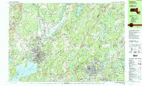
1988 Map of Hudson
USGS Topo · Published 1988About this map
Clinton and Hudson anchor this 1988 topographic survey of the industrial and residential heart of Worcester County and Middlesex County. The landscape is dominated by the sprawling Wachusett Reservoir to the southwest, featuring Cemetery Island and Cunningham Ledge. This era shows a region balanced between its manufacturing roots and the preservation of open spaces, with the Bolton Flats State Wildlife Management Area and Oxbow National Wildlife Refuge protecting the banks of the Nashua River.
Find a feature on this map
126 named features on this map. Tap any name to fly to it.
Don’t see what you’re looking for? This feature index may not catch every label — zoom into the map to look around manually.
Map Details
Editions of this 1988 Hudson Map
2 editions found
Other maps of this area

1885 · Worcester
USGS Topo · 1:62,500

1886 · Worcester
USGS Topo · 1:62,500

1886 · Lowell
USGS Topo · 1:62,500

1886 · Framingham
USGS Topo · 1:62,500

1887 · Marlboro
USGS Topo · 1:62,500

1887 · Fitchburg
USGS Topo · 1:62,500

1889 · Marlboro
USGS Topo · 1:62,500

1889 · Fitchburg
USGS Topo · 1:62,500

1889 · Framingham
USGS Topo · 1:62,500

1892 · Worcester
USGS Topo · 1:62,500