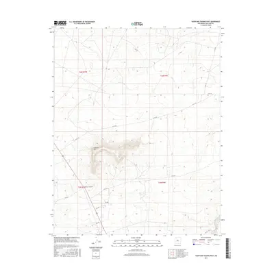
2017 Map of Huerfano Trading Post
USGS Topo · Published 2017About this map
Huerfano Mtn dominates the high desert landscape of San Juan County, rising as a prominent volcanic landmark within the Eastern Navajo Agency. Near its base, the Huerfano Trading Post serves as a modern focal point for local commerce and navigation, situated at a junction of regional transit. The layout of the territory is defined by an extensive grid of service and county roads, such as Co Rd 7425 and Co Rd 7575, which navigate the mesas and arroyos. This 2017 survey reflects the persistent importance of isolated trading centers in supporting dispersed communities, documenting the infrastructure that connects this arid portion of New Mexico across townships t26n r10w and t26n r9w.
Find a feature on this map
15 named features on this map. Tap any name to fly to it.
Don’t see what you’re looking for? This feature index may not catch every label — zoom into the map to look around manually.
Map Details
Editions of this 2017 Huerfano Trading Post Map
This is the sole edition of this map. No revisions or reprints were ever made.
Other maps of this area

1889 · Largo
USGS Topo · 1:250,000

1895 · Largo
USGS Topo · 1:250,000

1954 · Aztec
USGS Topo · 1:250,000

1958 · Aztec
USGS Topo · 1:250,000

1959 · Gould Pass
USGS Topo · 1:62,500

1959 · Nageezi
USGS Topo · 1:62,500

1960 · Bloomfield
USGS Topo · 1:62,500

1962 · Aztec
USGS Topo · 1:250,000

1965 · Aztec
USGS Topo · 1:250,000
1966 · Huerfano Trading Post SW
USGS Topo · 1:24,000
Featured Places
- Eastern Navajo Agency, NM
- Huerfano Trading Post, NM
- Dzilth-Na-O-Dith-Hle, NM
- San Juan County, NM
- United States