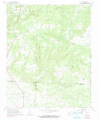
1965 Map of Huff
USGS Topo · Published 1990About this map
Uncle Joe Warren Mountain and Major Harris Mountain define the high ground of this mid-1960s landscape where the borders of Independence, White, and Jackson Counties converge. Small agrarian communities and family settlements are scattered throughout the hills, connected by winding roads and a prominent north-south pipeline. Local life centers around rural institutions such as Cornerstone Ch, Mt Calvary Ch, and Sunnyside Ch, while the region's burial grounds, including Riddles Cem and Putman Cem, provide a clear record of established family lineages. In the northwest, a Shale Pit and Huff Cem sit near the settlement of Huff, while the southern reaches near Midway and Denmark transition into the drainages of Coon Creek and Glaise Creek. The numerous hollows, such as Turkey Pen Hollow and Sinclair Hollow, illustrate how the drainage patterns of Departee Creek and Village Creek have historically dictated movement and settlement across these Arkansas uplands.
Find a feature on this map
45 named features on this map. Tap any name to fly to it.
Don’t see what you’re looking for? This feature index may not catch every label — zoom into the map to look around manually.
Map Details
Editions of this 1965 Huff Map
2 editions found
Other maps of this area

1890 · Batesville
USGS Topo · 1:125,000

1891 · Batesville
USGS Topo · 1:125,000

1935 · Newport
USGS Topo · 1:62,500

1935 · Augusta
USGS Topo · 1:62,500

1935 · Bald Knob
USGS Topo · 1:62,500

1942 · Jamestown
USGS Topo · 1:31,680

1942 · Salado
USGS Topo · 1:31,680

1953 · Memphis
USGS Topo · 1:250,000

1956 · Memphis
USGS Topo · 1:250,000
1956 · Newark
USGS Topo · 1:24,000