
1971 Map of Huff
USGS Topo · Published 1973About this map
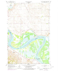
Huff stands on the western terrace above the Missouri River in this 1971 survey, just as the regional landscape was adjusting to the formation of Lake Oahe. The map documents a rugged upland terrain defined by isolated high points such as Ambulance Butte, Signal Butte, and Rattlesnake Butte, which served as critical landmarks for early navigation and surveying. A significant historical marker, the Old Fort Rice Military Reservation Boundary, cuts across the landscape, preserving the footprint of 19th-century frontier defense long after the fort's active years.
Find a feature on this map
18 named features on this map. Tap any name to fly to it.
Don’t see what you’re looking for? This feature index may not catch every label — zoom into the map to look around manually.
Map Details
Editions of this 1971 Huff Map
This is the sole edition of this map. No revisions or reprints were ever made.
Other maps of this area

1907 · Bismarck
USGS Topo · 1:125,000

1954 · Bismarck
USGS Topo · 1:250,000

1958 · Bismarck
USGS Topo · 1:250,000

1962 · Sugarloaf Butte
USGS Topo · 1:24,000

1962 · Schmidt
USGS Topo · 1:24,000

1968 · Cannon Ball
USGS Topo · 1:24,000

1968 · Cannon Ball NW
USGS Topo · 1:24,000

1971 · Fort Rice
USGS Topo · 1:24,000

1971 · Huff NE
USGS Topo · 1:24,000
1976 · Sugarloaf Butte
USGS Topo · 1:24,000