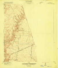
1916 Map of Huffman
USGS Topo · Published 1916About this map
Huffman and Bradford serve as the primary focal points of this 1916 survey, illustrating the early development of northeastern Harris County before the regional landscape was significantly altered by modern infrastructure. The Beaumont Sour Lake and Western railroad cuts across the southern portion of the sheet, providing a vital industrial link between the settlements. This transportation corridor is closely tied to the natural drainage systems of the area, including Luce Bayou and Cedar Bayou, which define the low-lying terrain. To the west, the East Fork San Jacinto River and features like Red Gully characterize the hydrologic network of the coastal plain. The presence of Moonshine Hill on the western margin suggests the proximity of the era's significant oil industry, while the rest of the quadrangle remains dominated by the intersection of rail and water.
Find a feature on this map
11 named features on this map. Tap any name to fly to it.
Don’t see what you’re looking for? This feature index may not catch every label — zoom into the map to look around manually.
Map Details
Editions of this 1916 Huffman Map
3 editions found
Other maps of this area

1916 · Crosby
USGS Topo · 1:24,000

1916 · Harmaston
USGS Topo · 1:24,000

1916 · Moonshine Hill
USGS Topo · 1:24,000

1916 · Huffman
USGS Topo · 1:24,000

1919 · Crosby
USGS Topo · 1:31,680

1920 · Harmaston
USGS Topo · 1:31,680

1920 · Moonshine Hill
USGS Topo · 1:31,680

1920 · Huffman
USGS Topo · 1:31,680

1943 · Liberty
USGS Topo · 1:125,000
1944 · Crosby
USGS Topo · 1:31,680