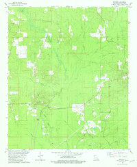
1981 Map of Hughes
USGS Topo · Published 1981About this map
St Louis Southwestern rail lines cut through the heart of northern Bossier Parish, connecting small rural communities and industrial outposts. The landscape is defined by the winding paths of Cypress Bayou and its many tributaries, including Little Cypress Bayou and Collinsburg Creek. Small settlements like Collinsburg, Alden Bridge, and Swindleville are centers of community life, each marked by historical landmarks such as Collinsburg Cem and a high concentration of local churches, including New Hope Ch and Sunflower Ch. Energy production is a visible part of the regional economy, with infrastructure supporting the Benton Oil and Gas Field and the Cottage Grove Oil and Gas Field appearing across the terrain. From Bookers Chapel to Dove Dale Cem, this 1980s record captures the established cultural and industrial geography of the Louisiana backcountry.
Find a feature on this map
34 named features on this map. Tap any name to fly to it.
Don’t see what you’re looking for? This feature index may not catch every label — zoom into the map to look around manually.
Map Details
Editions of this 1981 Hughes Map
This is the sole edition of this map. No revisions or reprints were ever made.
Other maps of this area

1932 · Hosston NE
USGS Topo · 1:31,680

1932 · Bossier NE
USGS Topo · 1:31,680

1932 · Hosston SE
USGS Topo · 1:31,680

1932 · Bossier NW
USGS Topo · 1:31,680

1932 · Shreveport NE
USGS Topo · 1:31,680

1948 · Mooringsport
USGS Topo · 1:62,500

1948 · Vivian
USGS Topo · 1:62,500

1948 · Bossier City
USGS Topo · 1:62,500

1950 · Plain Dealing SW
USGS Topo · 1:31,680

1950 · Plain Dealing NE
USGS Topo · 1:31,680