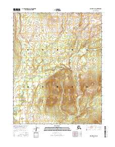
2016 Map of Hughes C-4 SE
USGS Topo · Published 2016About this map
Klikhtentotzna Creek defines the hydrography of this interior Alaskan landscape, meandering through the western portions of the quadrangle. This 2016 survey documents the vast, unnamed highlands of the Yukon-Koyukuk region, where the drainage of Klikhtentotzna Cr meets the southern terrain shaped by Gukhzna Cr. The map is primarily characterized by its remote natural features, lacking established settlements or road infrastructure, which highlights the area's isolation within the Public Land Survey System grids of t14n r19e and t13n r20e. For those studying the subarctic wilderness or tracing the exact path of interior waterways, the detailed contour intervals provide a precise record of the elevation changes across these prominent ridgelines and creek basins.
Find a feature on this map
7 named features on this map. Tap any name to fly to it.
Don’t see what you’re looking for? This feature index may not catch every label — zoom into the map to look around manually.
Map Details
Editions of this 2016 Hughes C-4 SE Map
This is the sole edition of this map. No revisions or reprints were ever made.
Other maps of this area

1951 · Hughes
USGS Topo · 1:250,000

1956 · Hughes
USGS Topo · 1:250,000

1964 · Hughes
USGS Topo · 1:250,000

1965 · Hughes
USGS Topo · 1:250,000
1986 · Hughes B-4
USGS Topo · 1:63,360
1986 · Hughes C-3
USGS Topo · 1:63,360
1986 · Hughes C-4
USGS Topo · 1:63,360
1986 · Hughes B-3
USGS Topo · 1:63,360
2016 · Hughes C-4 NW
USGS Topo · 1:25,000
2016 · Hughes C-4 NE
USGS Topo · 1:25,000