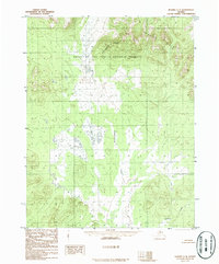
1986 Map of Hughes C-4
USGS Topo · Published 1986About this map
Continental Divide winds through this interior Alaskan wilderness, marking a significant hydrologic boundary within the Gates of the Arctic National Preserve. Published in the mid-1980s, the map reflects a landscape defined by its hydrography and elevation, where Klikhtentotzna Creek and Gukhzna Creek drain the surrounding slopes. The Norutak Hills dominate the northeastern portion of the quadrangle, illustrating the complex topography that characterizes this subarctic region. The presence of the national preserve boundary highlights the era of federal land conservation following the Alaska National Interest Lands Conservation Act of 1980, which formally established these protected borders.
Find a feature on this map
5 named features on this map. Tap any name to fly to it.
Don’t see what you’re looking for? This feature index may not catch every label — zoom into the map to look around manually.
Map Details
Editions of this 1986 Hughes C-4 Map
This is the sole edition of this map. No revisions or reprints were ever made.
Other maps of this area

1951 · Hughes
USGS Topo · 1:250,000

1956 · Hughes
USGS Topo · 1:250,000

1964 · Hughes
USGS Topo · 1:250,000

1965 · Hughes
USGS Topo · 1:250,000
1986 · Hughes B-4
USGS Topo · 1:63,360
1986 · Hughes D-5
USGS Topo · 1:63,360
1986 · Hughes C-3
USGS Topo · 1:63,360
1986 · Hughes B-5
USGS Topo · 1:63,360
1986 · Hughes D-4
USGS Topo · 1:63,360
1986 · Hughes C-5
USGS Topo · 1:63,360