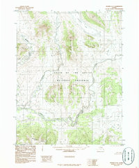
1986 Map of Hughes D-4
USGS Topo · Published 1986About this map
Gates of the Arctic National Preserve dominates this mid-1980s topographic record of the Alaskan wilderness. The landscape is defined by the powerful eastward flow of the Kobuk River, which cuts through the southern portion of the sheet and narrows into the Lower Kobuk Canyon. The hydrological network here is dense, with the Reed River and Beaver Creek draining the high ground of the Akoliakruich Hills.
Find a feature on this map
8 named features on this map. Tap any name to fly to it.
Don’t see what you’re looking for? This feature index may not catch every label — zoom into the map to look around manually.
Map Details
Editions of this 1986 Hughes D-4 Map
This is the sole edition of this map. No revisions or reprints were ever made.
Other maps of this area

1951 · Hughes
USGS Topo · 1:250,000

1951 · Survey Pass
USGS Topo · 1:250,000

1956 · Hughes
USGS Topo · 1:250,000

1956 · Survey Pass
USGS Topo · 1:250,000

1964 · Survey Pass
USGS Topo · 1:250,000

1964 · Hughes
USGS Topo · 1:250,000

1965 · Hughes
USGS Topo · 1:250,000

1966 · Survey Pass
USGS Topo · 1:250,000
1986 · Survey Pass A-5
USGS Topo · 1:63,360
1986 · Survey Pass A-4
USGS Topo · 1:63,360