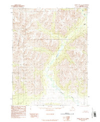
1986 Map of Survey Pass A-5
USGS Topo · Published 1986About this map
Beaver Creek flows through the central drainage of this Northwest Arctic landscape, captured here as it appeared in the late 1970s. The terrain is defined by high alpine ridges and remote glacial passes, most notably Akurekvik Pass in the northeast corner of the quadrangle. This 1986 provisional edition was compiled from 1978 aerial photography by the Usgs and the Bureau of Land Management, representing a period of meticulous wilderness mapping before modern digital updates. The drainage of the Reed River is visible in the upper right, cutting through the high country. As a provisional map, it preserves the raw topographic data and original manuscript drawings of the era, focusing on the natural hydrology and landforms of this roadless region where no man-made structures or trails were recorded at the time of survey.
Find a feature on this map
3 named features on this map. Tap any name to fly to it.
Don’t see what you’re looking for? This feature index may not catch every label — zoom into the map to look around manually.
Map Details
Editions of this 1986 Survey Pass A-5 Map
This is the sole edition of this map. No revisions or reprints were ever made.
Other maps of this area

1951 · Hughes
USGS Topo · 1:250,000

1951 · Survey Pass
USGS Topo · 1:250,000

1956 · Hughes
USGS Topo · 1:250,000

1956 · Survey Pass
USGS Topo · 1:250,000

1964 · Survey Pass
USGS Topo · 1:250,000

1964 · Hughes
USGS Topo · 1:250,000

1965 · Hughes
USGS Topo · 1:250,000

1966 · Survey Pass
USGS Topo · 1:250,000
1986 · Survey Pass A-4
USGS Topo · 1:63,360
1986 · Hughes D-5
USGS Topo · 1:63,360