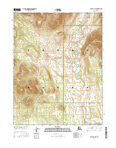
2016 Map of Hughes C-4 NW
USGS Topo · Published 2016About this map
The boundary between the Northwest Arctic Borough and the Yukon-Koyukuk Census Area bisects this remote subarctic landscape, where high ridgelines descend into expansive wetlands. Much of the western terrain is protected within the Gates of the Arctic National Preserve, a designation that maintains the area's wilderness character by limiting commercial development. In the southeast, the drainage of Klikhtentotzna Cr meanders through lower elevations, providing a critical hydrological feature in an otherwise high-relief region defined by complex topographic contours. This survey illustrates the intersection of administrative census lines and natural preserve boundaries in a part of Alaska where human infrastructure is entirely absent, replaced by a dense network of seasonal streams and glacial landforms.
Find a feature on this map
9 named features on this map. Tap any name to fly to it.
Don’t see what you’re looking for? This feature index may not catch every label — zoom into the map to look around manually.
Map Details
Editions of this 2016 Hughes C-4 NW Map
This is the sole edition of this map. No revisions or reprints were ever made.
Other maps of this area

1951 · Hughes
USGS Topo · 1:250,000

1956 · Hughes
USGS Topo · 1:250,000

1964 · Hughes
USGS Topo · 1:250,000

1965 · Hughes
USGS Topo · 1:250,000
1986 · Hughes D-5
USGS Topo · 1:63,360
1986 · Hughes D-4
USGS Topo · 1:63,360
1986 · Hughes C-5
USGS Topo · 1:63,360
1986 · Hughes C-4
USGS Topo · 1:63,360
2016 · Hughes D-5 SE
USGS Topo · 1:25,000
2016 · Hughes C-5 NE
USGS Topo · 1:25,000