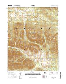
2016 Map of Hughes C-5 NE
USGS Topo · Published 2016About this map
The Continental Divide traverses this remote stretch of the Alaska wilderness within the Gates of the Arctic National Preserve. This landscape is defined by its extreme topography, where water flows in opposite directions toward the Arctic and Pacific drainages. Rising in the southwest corner, Mt Ekron stands as a prominent topographical landmark among the complex drainage basins of the Northwest Arctic Borough. The map serves as a detailed survey of the Public Land Survey System grids, specifically documenting townships from t16n r17e through t14n r18e. This 2016 edition provides a modern inventory of the untouched terrain before further environmental shifts, offering researchers a precise look at the elevation and hydrology of one of the most protected wilderness areas in the United States.
Find a feature on this map
9 named features on this map. Tap any name to fly to it.
Don’t see what you’re looking for? This feature index may not catch every label — zoom into the map to look around manually.
Map Details
Editions of this 2016 Hughes C-5 NE Map
This is the sole edition of this map. No revisions or reprints were ever made.
Other maps of this area

1951 · Hughes
USGS Topo · 1:250,000

1956 · Hughes
USGS Topo · 1:250,000

1964 · Hughes
USGS Topo · 1:250,000

1965 · Hughes
USGS Topo · 1:250,000
1986 · Hughes D-5
USGS Topo · 1:63,360
1986 · Hughes D-4
USGS Topo · 1:63,360
1986 · Hughes C-5
USGS Topo · 1:63,360
1986 · Hughes C-4
USGS Topo · 1:63,360
2016 · Hughes D-5 SE
USGS Topo · 1:25,000
2016 · Hughes D-5 SW
USGS Topo · 1:25,000