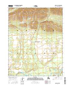
2016 Map of Hughes D-5 SW
USGS Topo · Published 2016About this map
Gates Of The Arctic National Preserve dominates the central landscape of this Northwest Arctic quadrangle, where the transition from high mountain ridges to the river valley is clearly defined. The terrain is shaped by several significant watercourses, most notably the Kobuk River as it winds through the southern portion of the sheet. Within the river's path, Bear Island sits as a prominent landform, while the Akpelik Cr and Angayukachak Cr drain the higher elevations to the north. This 2016 survey illustrates the pristine state of the Alaskan interior, showing a landscape defined entirely by its natural hydrology and the vast protections of the National Preserve, with no roads or permanent settlements present on the land.
Find a feature on this map
9 named features on this map. Tap any name to fly to it.
Don’t see what you’re looking for? This feature index may not catch every label — zoom into the map to look around manually.
Map Details
Editions of this 2016 Hughes D-5 SW Map
This is the sole edition of this map. No revisions or reprints were ever made.
Other maps of this area

1951 · Hughes
USGS Topo · 1:250,000

1956 · Hughes
USGS Topo · 1:250,000

1964 · Hughes
USGS Topo · 1:250,000

1965 · Hughes
USGS Topo · 1:250,000
1986 · Hughes D-5
USGS Topo · 1:63,360
1986 · Hughes C-5
USGS Topo · 1:63,360
1986 · Hughes D-6
USGS Topo · 1:63,360
1986 · Hughes C-6
USGS Topo · 1:63,360
2016 · Hughes D-5 NE
USGS Topo · 1:25,000
2016 · Hughes C-6 NE
USGS Topo · 1:25,000