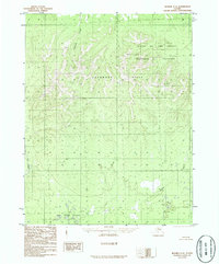
1986 Map of Hughes C-6
USGS Topo · Published 1986About this map
Gates Of The Arctic National Preserve occupies the northeastern corner of this remote Alaskan interior landscape, where the terrain shifts from the prominent ridges of the Lockwood Hills to the extensive wetland systems of the Pah River Flats in the south. The hydrography of the region is defined by the Pah River, which meanders along the western boundary, and the Holly Lakes tucked into the southeastern corner.
Find a feature on this map
14 named features on this map. Tap any name to fly to it.
Don’t see what you’re looking for? This feature index may not catch every label — zoom into the map to look around manually.
Map Details
Editions of this 1986 Hughes C-6 Map
This is the sole edition of this map. No revisions or reprints were ever made.
Other maps of this area

1951 · Shungnak
USGS Topo · 1:250,000

1951 · Hughes
USGS Topo · 1:250,000

1955 · Shungnak
USGS Topo · 1:250,000

1956 · Hughes
USGS Topo · 1:250,000

1964 · Shungnak
USGS Topo · 1:250,000

1964 · Hughes
USGS Topo · 1:250,000

1965 · Hughes
USGS Topo · 1:250,000
1985 · Shungnak D-1
USGS Topo · 1:63,360
1985 · Shungnak B-1
USGS Topo · 1:63,360
1985 · Shungnak C-1
USGS Topo · 1:63,360