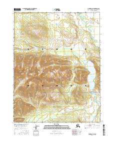
2016 Map of Hughes D-5 NE
USGS Topo · Published 2016About this map
Gates Of The Arctic National Preserve covers the southern portion of this interior landscape, where the northernmost reaches of the Koyukuk River drainage begin to take shape. The terrain is dominated by the expansive Lake Minakokosa to the east, a significant water body situated against the backdrop of rising elevation. To the west, the drainage of Akpelik Cr carves through the topographic contours, while the meandering path of Beaver Creek defines the northeastern corner. This 2016 survey documents a region of Alaska where modern federal land management boundaries meet the traditional Public Land Survey System, illustrating the intersection of conservation areas and township grids such as t18n r17e and t19n r18e.
Find a feature on this map
11 named features on this map. Tap any name to fly to it.
Don’t see what you’re looking for? This feature index may not catch every label — zoom into the map to look around manually.
Map Details
Editions of this 2016 Hughes D-5 NE Map
This is the sole edition of this map. No revisions or reprints were ever made.
Other maps of this area

1951 · Hughes
USGS Topo · 1:250,000

1951 · Survey Pass
USGS Topo · 1:250,000

1956 · Hughes
USGS Topo · 1:250,000

1956 · Survey Pass
USGS Topo · 1:250,000

1964 · Survey Pass
USGS Topo · 1:250,000

1964 · Hughes
USGS Topo · 1:250,000

1965 · Hughes
USGS Topo · 1:250,000

1966 · Survey Pass
USGS Topo · 1:250,000
1986 · Survey Pass A-5
USGS Topo · 1:63,360
1986 · Survey Pass A-4
USGS Topo · 1:63,360