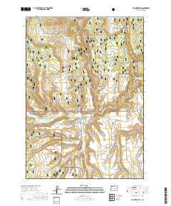
2020 Map of Hughet Valley
USGS Topo · Published 2020About this map
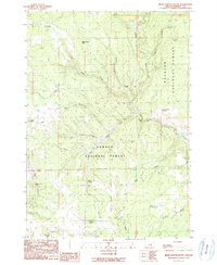
The high desert and timbered slopes of Harney County are defined here by the meeting of the Malheur National Forest and Ochoco National Forest. This remote interior landscape in the Hughet Valley region is marked by an extensive network of springs and reservoirs critical for livestock and wildlife, including Rocking Bar Spring, Blue Creek Spring, and the Seven Up Spring. The water management system is further detailed through features like Beaverdam Reservoir and Emigrant Reservoir. Transportation through this often-rugged terrain relies on specialized routes such as Hines Logging Rd and Emigrant Creek Rd, which follow the natural contours of the drainages. The map reveals how water sources like Professor Spring and Smith Reservoir dictate the movement and utility of this eastern Oregon high country.
Find a feature on this map
53 named features on this map. Tap any name to fly to it.
Don’t see what you’re looking for? This feature index may not catch every label — zoom into the map to look around manually.
Map Details
Editions of this 2020 Hughet Valley Map
This is the sole edition of this map. No revisions or reprints were ever made.
Other maps of this area

1955 · Burns
USGS Topo · 1:250,000

1958 · Burns
USGS Topo · 1:250,000

1959 · Burns
USGS Topo · 1:250,000

1959 · West Myrtle Butte
USGS Topo · 1:62,500

1959 · Sawtooth Creek
USGS Topo · 1:62,500

1960 · Burns
USGS Topo · 1:62,500
1981 · Egypt Canyon
USGS Topo · 1:24,000
1981 · Holmes Canyon
USGS Topo · 1:24,000
1990 · Burns NW
USGS Topo · 1:24,000
1990 · Bear Canyon Butte
USGS Topo · 1:24,000