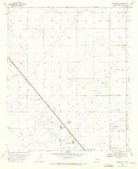
1969 Map of Humble City
USGS Topo · Published 1972About this map
Crossroads International Airport and its adjacent Landing Strips dominate the southern landscape of this Lea County plateau, reflecting the mid-century aviation and educational expansion of the region. The map captures a high concentration of institutional development, featuring both the College of the Southwest and New Mexico Junior College near Air Base City. This concentration of infrastructure sits in stark contrast to the surrounding terrain, which is punctuated by dozens of individual wells and several Gravel Pit operations.
Find a feature on this map
15 named features on this map. Tap any name to fly to it.
Don’t see what you’re looking for? This feature index may not catch every label — zoom into the map to look around manually.
Map Details
Editions of this 1969 Humble City Map
4 editions found
Other maps of this area

1954 · Hobbs
USGS Topo · 1:250,000

1958 · Hobbs
USGS Topo · 1:250,000

1962 · Lovington
USGS Topo · 1:24,000

1962 · Lovington
USGS Topo · 1:62,500

1963 · Monument
USGS Topo · 1:62,500

1969 · Humble City
USGS Topo · 1:24,000

1969 · Hobbs East
USGS Topo · 1:24,000

1969 · Humble City NE
USGS Topo · 1:24,000

1969 · Hobbs West
USGS Topo · 1:24,000

1969 · Humble City SE
USGS Topo · 1:24,000