
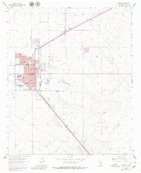
1962 Map of Lovington
USGS Topo · Published 1964About this map
Lovington serves as the central hub of this 1960s survey, characterized by its grid of residential streets and essential civic infrastructure. The town layout is anchored by institutions like City Hall, the Hospital, and several educational facilities including Lea Sch, Taylor Jr High Sch, and Parkview Sch. The landscape surrounding the town reveals the economic drivers of the era, dominated by energy production and ranching. The Texas New Mexico railroad line cuts diagonally through the southern plains, connecting the urban center to the industrial activity of the Dean Oil Field and East Lovington Oil Field.
Find a feature on this map
41 named features on this map. Tap any name to fly to it.
Don’t see what you’re looking for? This feature index may not catch every label — zoom into the map to look around manually.
Map Details
Editions of this 1962 Lovington Map
2 editions found
Other maps of this area

1954 · Hobbs
USGS Topo · 1:250,000

1954 · Brownfield
USGS Topo · 1:250,000

1958 · Brownfield
USGS Topo · 1:250,000

1958 · Hobbs
USGS Topo · 1:250,000

1962 · Brownfield
USGS Topo · 1:250,000

1962 · Lovington
USGS Topo · 1:62,500

1969 · Humble City
USGS Topo · 1:24,000

1970 · Prairieview
USGS Topo · 1:24,000

1970 · Hillburn City
USGS Topo · 1:24,000

1970 · Hillburn City SW
USGS Topo · 1:24,000