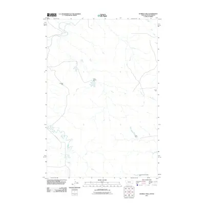
2011 Map of Humbolt Hills
USGS Topo · Published 2011About this map
The Humbolt Hills provide the defining elevation in this corner of Carter County, Montana, just west of the South Dakota border. This landscape is characterized by a high-plains water management network, where numerous small-scale reservoirs like Ernest Wallstein Dam, Holsti Dam, and Scoria Dam have been constructed to capture runoff in a semi-arid environment. These features, along with the Evenson North Irrigation Dam, illustrate the critical importance of water storage for local agriculture and livestock. The area is drained by Boxelder Creek and Stony Creek, while the presence of Mill Iron Rd in the southwest corner connects the remote terrain to the wider region. The map captures the intersection of natural drainage and human engineering at the start of the 21st century.
Find a feature on this map
8 named features on this map. Tap any name to fly to it.
Don’t see what you’re looking for? This feature index may not catch every label — zoom into the map to look around manually.
Map Details
Editions of this 2011 Humbolt Hills Map
This is the sole edition of this map. No revisions or reprints were ever made.
Other maps of this area

1935 · Buffalo
USGS Topo · 1:125,000

1954 · Lemmon
USGS Topo · 1:250,000

1954 · Ekalaka
USGS Topo · 1:250,000

1956 · Ekalaka
USGS Topo · 1:250,000

1957 · Lemmon
USGS Topo · 1:250,000

1958 · Ekalaka
USGS Topo · 1:250,000

1965 · Ekalaka
USGS Topo · 1:250,000

1974 · Caroline Butte
USGS Topo · 1:24,000
1977 · Scott Creek
USGS Topo · 1:24,000
1977 · Doaks Butte
USGS Topo · 1:24,000