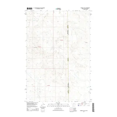
2014 Map of Humbolt Hills
USGS Topo · Published 2014About this map
Humbolt Hills dominates the central topography of this high plains region where the borders of Montana and South Dakota meet. The landscape is defined by the drainage patterns of Boxelder Creek in the north and the seasonal watercourses of Seal Draw and Stony Cr to the east. This section of the frontier is delineated by the prominent north-south boundary line between Montana and South Dakota, specifically marking the divide between Carter County and Harding County. The terrain is characterized by intricate contour intervals that reveal the complex relief of the hills, showing an area largely defined by its natural landforms rather than dense settlement. The map provides a precise look at the Public Land Survey System grid, including townships t1n r61e, t1n r62e, and t1s r62e, which historically organized the ranching and homesteading tracts of the western territory.
Find a feature on this map
9 named features on this map. Tap any name to fly to it.
Don’t see what you’re looking for? This feature index may not catch every label — zoom into the map to look around manually.
Map Details
Editions of this 2014 Humbolt Hills Map
This is the sole edition of this map. No revisions or reprints were ever made.
Other maps of this area

1935 · Buffalo
USGS Topo · 1:125,000

1954 · Lemmon
USGS Topo · 1:250,000

1954 · Ekalaka
USGS Topo · 1:250,000

1956 · Ekalaka
USGS Topo · 1:250,000

1957 · Lemmon
USGS Topo · 1:250,000

1958 · Ekalaka
USGS Topo · 1:250,000

1965 · Ekalaka
USGS Topo · 1:250,000

1974 · Caroline Butte
USGS Topo · 1:24,000
1977 · Scott Creek
USGS Topo · 1:24,000
1977 · Doaks Butte
USGS Topo · 1:24,000