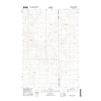
2017 Map of Humbolt Hills
USGS Topo · Published 2017About this map
Humbolt Hills dominates the central landscape of this borderland region, where the high plains of Montana meet the western edge of South Dakota. The terrain is defined by a network of drainage patterns and intermittent waterways, including the winding course of Boxelder Creek in the northwest and Spring Creek further south. This 2017 survey illustrates a sparse, wide-open landscape primarily utilized for ranching and transit, centered around the Carter County and Harding County line. Human infrastructure is limited but significant, centered on the corridor of Mill Iron Rd which traverses the southwestern quadrant. Topographic details such as Seal Draw reveal the intricate erosional features characteristic of this semi-arid environment, providing a clear record of the physical geography at the state junction.
Find a feature on this map
12 named features on this map. Tap any name to fly to it.
Don’t see what you’re looking for? This feature index may not catch every label — zoom into the map to look around manually.
Map Details
Editions of this 2017 Humbolt Hills Map
This is the sole edition of this map. No revisions or reprints were ever made.
Other maps of this area

1935 · Buffalo
USGS Topo · 1:125,000

1954 · Lemmon
USGS Topo · 1:250,000

1954 · Ekalaka
USGS Topo · 1:250,000

1956 · Ekalaka
USGS Topo · 1:250,000

1957 · Lemmon
USGS Topo · 1:250,000

1958 · Ekalaka
USGS Topo · 1:250,000

1965 · Ekalaka
USGS Topo · 1:250,000

1974 · Caroline Butte
USGS Topo · 1:24,000
1977 · Scott Creek
USGS Topo · 1:24,000
1977 · Doaks Butte
USGS Topo · 1:24,000