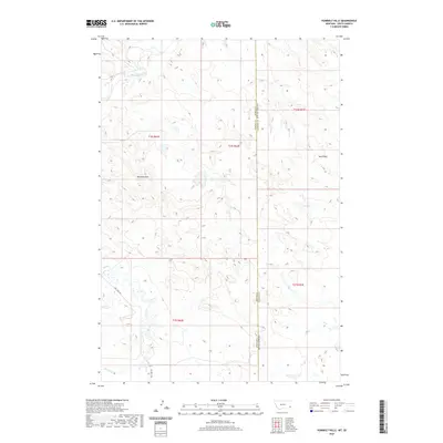
2020 Map of Humbolt Hills
USGS Topo · Published 2020About this map
Humbolt Hills dominates this high-plains landscape along the border of Carter County, Montana, and Harding County, South Dakota. This remote borderland is defined by a series of intermittent watercourses that drain the surrounding ridges, including Boxelder Creek, Stony Cr, and Spring Cr. The land is sparsely marked by infrastructure, with Mill Iron Rd providing the primary access through the southwestern portion of the quadrangle. The grid-like division of public lands is clearly delineated by township and range markers such as t1n r62e and t22n r1e. The topographic detail highlights the complex drainage patterns and coulees like Seal Draw, illustrating the stark and functional geography of the American West as it appeared during the 2020 survey.
Find a feature on this map
13 named features on this map. Tap any name to fly to it.
Don’t see what you’re looking for? This feature index may not catch every label — zoom into the map to look around manually.
Map Details
Editions of this 2020 Humbolt Hills Map
This is the sole edition of this map. No revisions or reprints were ever made.
Other maps of this area

1935 · Buffalo
USGS Topo · 1:125,000

1954 · Lemmon
USGS Topo · 1:250,000

1954 · Ekalaka
USGS Topo · 1:250,000

1956 · Ekalaka
USGS Topo · 1:250,000

1957 · Lemmon
USGS Topo · 1:250,000

1958 · Ekalaka
USGS Topo · 1:250,000

1965 · Ekalaka
USGS Topo · 1:250,000

1974 · Caroline Butte
USGS Topo · 1:24,000
1977 · Scott Creek
USGS Topo · 1:24,000
1977 · Doaks Butte
USGS Topo · 1:24,000