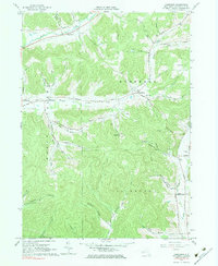
1961 Map of Humphrey
USGS Topo · Published 1983About this map
The Mount Echo Bible Institute stands at the heart of this landscape, surrounded by the narrow valleys and steep hills of the Southern Tier. Small rural clusters like Humphrey and Humphrey Center are connected by winding roads that trace the contours of the terrain, while the settlement of Sugartown occupies the northern reaches of the quadrangle. The area's mid-century economy is clearly visible through the numerous Oil Wells scattered across the central hills, particularly around Pumpkin Hollow and Wrights Creek. Local history is anchored by several sites of worship and rest, including St Pacificus Ch and the Fivemile Cem. The map's fine red dashed lines indicate fence and field divisions visible during the 1960 aerial photogrammetric survey, providing a detailed record of land use and property boundaries in this part of Cattaraugus County.
Find a feature on this map
58 named features on this map. Tap any name to fly to it.
Don’t see what you’re looking for? This feature index may not catch every label — zoom into the map to look around manually.
Map Details
Editions of this 1961 Humphrey Map
4 editions found
Other maps of this area

1898 · Olean
USGS Topo · 1:62,500

1900 · Salamanca
USGS Topo · 1:62,500

1924 · Ellicottville
USGS Topo · 1:62,500

1924 · Franklinville
USGS Topo · 1:62,500

1938 · Salamanca
USGS Topo · 1:62,500

1938 · Olean
USGS Topo · 1:62,500

1941 · Ellicottville
USGS Topo · 1:62,500

1942 · Franklinville
USGS Topo · 1:62,500

1943 · Olean
USGS Topo · 1:62,500

1943 · Salamanca
USGS Topo · 1:62,500