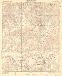
1932 Map of Humphreys
USGS Topo · Published 1932About this map
The Santa Clara River and the Southern Pacific railroad corridor dictate the settlement patterns of this northern Los Angeles County landscape in the early 1930s. Small rail stops and agricultural clusters such as Honby, Solamint, and Humphreys follow the river valley, while the northern extent of the sheet is dominated by the steep, canyon-riven terrain of the Angeles National Forest. The map captures a transitional era for rural education, documenting several local schoolhouses including New Era Sch, Honby Sch, and Sulphur Spring Sch, which served families tucked into the various drainages like Bouquet Canyon and Texas Canyon. The newly surveyed Sierra Highway appears as a primary artery, cutting through the Sierra Pelona foothills and tracing the path of Mint Canyon Sch. The detailed topography illustrates how water and transportation routes were inseparable from the early development of these outlying canyon communities.
Find a feature on this map
19 named features on this map. Tap any name to fly to it.
Don’t see what you’re looking for? This feature index may not catch every label — zoom into the map to look around manually.
Map Details
Editions of this 1932 Humphreys Map
3 editions found
Other maps of this area

1900 · Fernando
USGS Topo · 1:62,500

1901 · Southern California Sheet No. 1
USGS Topo · 1:250,000

1903 · Tejon
USGS Topo · 1:125,000

1903 · Camulos
USGS Topo · 1:125,000

1903 · Santa Susana
USGS Topo · 1:62,500

1904 · Southern California Sheet No. 1
USGS Topo · 1:250,000

1915 · Elizabeth Lake
USGS Topo · 1:125,000

1917 · Elizabeth Lake
USGS Topo · 1:125,000

1925 · Sylmar
USGS Topo · 1:24,000

1928 · Sylmar
USGS Topo · 1:24,000