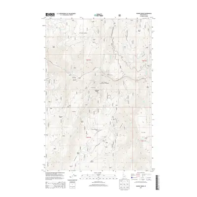
2013 Map of Hungry Ridge
USGS Topo · Published 2013About this map
The South Fork Clearwater River winds through the northern portion of this Idaho County landscape, serving as a primary corridor for recreation and travel along State Hwy 14. This terrain is defined by its deep drainages and prominent ridges, including Hungry Ridge and Quartz Ridge, which overlook a network of creeks such as Meadow Cr and Johns Cr. Located within the Nez Perce National Forest, the area maintains a character of working forest and private holdings, with family-named sites like Lamb Ranch and Gilmore Ranch anchoring the local history. Recreational infrastructure is concentrated near the river, featuring the Castle Creek Campground and South Fork Campground. The inclusion of the Hungry Ridge Ranch Airport and the distinctively named Asbestos Point highlights the intersection of private aviation and mineral history in this backcountry region.
Find a feature on this map
55 named features on this map. Tap any name to fly to it.
Don’t see what you’re looking for? This feature index may not catch every label — zoom into the map to look around manually.
Map Details
Editions of this 2013 Hungry Ridge Map
This is the sole edition of this map. No revisions or reprints were ever made.
Other maps of this area

1931 · Buffalo Hump
USGS Topo · 1:125,000

1934 · Buffalo Hump
USGS Topo · 1:125,000

1955 · Grangeville
USGS Topo · 1:250,000

1956 · Elk City
USGS Topo · 1:250,000

1959 · Grangeville
USGS Topo · 1:250,000

1960 · Elk City
USGS Topo · 1:250,000

1963 · Sourdough Peak
USGS Topo · 1:24,000

1963 · Goodwin Meadows
USGS Topo · 1:24,000

1963 · Huddleson Bluff
USGS Topo · 1:24,000
1963 · Hungry Ridge
USGS Topo · 1:24,000