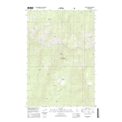
2017 Map of Hungry Ridge
USGS Topo · Published 2017About this map
The South Fork Clearwater River carves a deep valley through the northern half of this Idaho County landscape, serving as a primary drainage for the surrounding highlands. This terrain within the Nez Perce National Forest is defined by several prominent ridges, including Hungry Ridge, Quartz Ridge, and Tamarack Ridge. The map shows a network of remote access routes, such as the Hungry Ridge Rd and Nat For Dev Rd 309, which connect isolated clearings and meadows. Notable localized clearings include Earthquake Meadows and Buck Meadows, while human activity is centered at the Hungry Ridge Ranch Airport. Topographical landmarks like Asbestos Point and Jackass Gulch highlight the varied elevations of the Idaho wilderness, documented here as the forest service roads and natural waterways shaped the interior of the Clearwater basin.
Find a feature on this map
51 named features on this map. Tap any name to fly to it.
Don’t see what you’re looking for? This feature index may not catch every label — zoom into the map to look around manually.
Map Details
Editions of this 2017 Hungry Ridge Map
This is the sole edition of this map. No revisions or reprints were ever made.
Other maps of this area

1931 · Buffalo Hump
USGS Topo · 1:125,000

1934 · Buffalo Hump
USGS Topo · 1:125,000

1955 · Grangeville
USGS Topo · 1:250,000

1956 · Elk City
USGS Topo · 1:250,000

1959 · Grangeville
USGS Topo · 1:250,000

1960 · Elk City
USGS Topo · 1:250,000

1963 · Sourdough Peak
USGS Topo · 1:24,000

1963 · Goodwin Meadows
USGS Topo · 1:24,000

1963 · Huddleson Bluff
USGS Topo · 1:24,000
1963 · Hungry Ridge
USGS Topo · 1:24,000