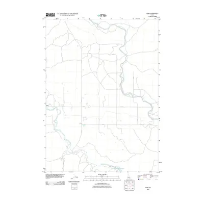
2010 Map of Hunt
USGS Topo · Published 2010About this map
The settlement of Hunt and its surrounding agricultural landscape are defined by a complex network of man-made waterways essential for irrigation in this part of Idaho. This 2010 survey shows the critical role of the Milner Gooding Canal as it winds through the northern and eastern portions of the quadrangle, while the North Side Main Canal provides the primary water source for the southern region. These engineering feats transformed the high desert into productive land, a transition punctuated by the Wilson Lake Reservoir and its associated Wilson Lake Dam in the southeast. The geometric precision of the landscape is further emphasized by the grid of local thoroughfares such as Hunt Rd, N Eden Rd, and S Eden Rd, alongside smaller distribution channels like Lateral 21.
Find a feature on this map
17 named features on this map. Tap any name to fly to it.
Don’t see what you’re looking for? This feature index may not catch every label — zoom into the map to look around manually.
Map Details
Editions of this 2010 Hunt Map
This is the sole edition of this map. No revisions or reprints were ever made.
Other maps of this area

1955 · Twin Falls
USGS Topo · 1:250,000

1958 · Twin Falls
USGS Topo · 1:250,000

1964 · Kimberly
USGS Topo · 1:24,000

1964 · Eden
USGS Topo · 1:24,000

1964 · Milner
USGS Topo · 1:24,000

1964 · Hazelton NE
USGS Topo · 1:24,000

1964 · Perrine
USGS Topo · 1:24,000

1964 · Hunt
USGS Topo · 1:24,000
1965 · Milner
USGS Topo · 1:24,000

1971 · Shoshone SE
USGS Topo · 1:24,000