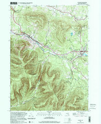
1997 Map of Hunter
USGS Topo · Published 2001About this map
Hunter and Tannersville serve as the primary anchors of this High Catskills landscape, where the local economy and culture are defined by the steep elevation changes between the Hunter Mountain Plateau and the valley floors. The map details a region balancing seasonal recreation with deep-rooted community foundations, evidenced by the cluster of churches like St Johns Ch and St Marys Ch, alongside specialized enclaves like Onteora Park and Elka Park.
Find a feature on this map
53 named features on this map. Tap any name to fly to it.
Don’t see what you’re looking for? This feature index may not catch every label — zoom into the map to look around manually.
Map Details
Editions of this 1997 Hunter Map
This is the sole edition of this map. No revisions or reprints were ever made.
Other maps of this area

1892 · Kaaterskill
USGS Topo · 1:62,500

1893 · Kaaterskill
USGS Topo · 1:62,500

1893 · Durham
USGS Topo · 1:62,500

1894 · Kaaterskill
USGS Topo · 1:62,500

1894 · Durham
USGS Topo · 1:62,500

1899 · Kaaterskill
USGS Topo · 1:62,500

1900 · Phoenicia
USGS Topo · 1:62,500

1901 · Gilboa
USGS Topo · 1:62,500

1903 · Gilboa
USGS Topo · 1:62,500

1903 · Phoenicia
USGS Topo · 1:62,500