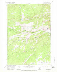
1967 Map of Hunter Mesa
USGS Topo · Published 1971About this map
Bighorn National Forest defines this high-elevation landscape, where deep drainages like North Clear Creek and South Clear Creek carve through the plateau. In the late 1960s, the area supported a mix of seasonal livestock operations and growing recreational use. Historic cattle ranching infrastructure is evident at the French Creek Cow Camp, Lucasta Camp, and the Cross H Cow Camp, while the Paradise Ranch suggests a shift toward the region's burgeoning guest ranch industry.
Find a feature on this map
81 named features on this map. Tap any name to fly to it.
Don’t see what you’re looking for? This feature index may not catch every label — zoom into the map to look around manually.
Map Details
Editions of this 1967 Hunter Mesa Map
2 editions found
Other maps of this area

1899 · Cloud peak
USGS Topo · 1:125,000

1900 · Fort McKinney
USGS Topo · 1:125,000

1901 · Cloud Peak
USGS Topo · 1:125,000

1903 · Fort McKinney
USGS Topo · 1:125,000

1955 · Sheridan
USGS Topo · 1:250,000

1958 · Sheridan
USGS Topo · 1:250,000

1962 · Sheridan
USGS Topo · 1:250,000

1967 · Lake De Smet West
USGS Topo · 1:24,000
1967 · Willow Park Reservoir
USGS Topo · 1:24,000

1967 · Caribou Creek
USGS Topo · 1:24,000