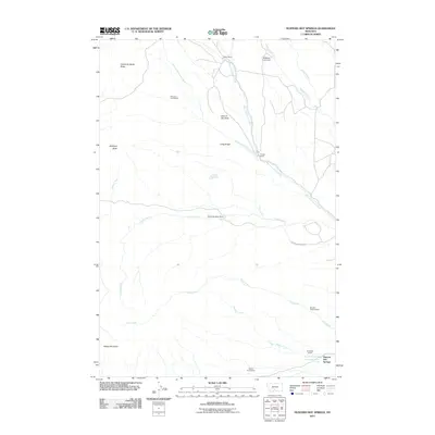
2011 Map of Hunters Hot Springs
USGS Topo · Published 2011About this map
Hunters Hot Springs serves as the focal point for this section of Park County, where the plains meet the foothills of the Gallatin Range. The landscape is defined by a deep-rooted ranching and homesteading history, evidenced by a high density of named family properties such as the Martel Homestead, Roebecker Homestead, and Prevost Homestead. These historic claims are interspersed with large-scale operations like the Sheep Mountain Ranch and the Murphy Sheep Sheds, illustrating the shift from early settlement to established agricultural production.
Find a feature on this map
24 named features on this map. Tap any name to fly to it.
Don’t see what you’re looking for? This feature index may not catch every label — zoom into the map to look around manually.
Map Details
Editions of this 2011 Hunters Hot Springs Map
This is the sole edition of this map. No revisions or reprints were ever made.
Other maps of this area

1891 · Livingston
USGS Topo · 1:250,000

1893 · Livingston
USGS Topo · 1:250,000

1947 · Bozeman
USGS Topo · 1:250,000

1948 · Bozeman
USGS Topo · 1:250,000

1951 · Ibex Mountain
USGS Topo · 1:24,000

1951 · Grannis
USGS Topo · 1:24,000
1951 · Raspberry Butte
USGS Topo · 1:24,000

1951 · Kelly Hills
USGS Topo · 1:24,000

1951 · Springdale
USGS Topo · 1:24,000

1951 · Hunters Hot Springs
USGS Topo · 1:24,000