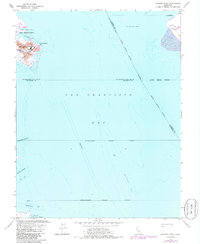
1956 Map of Hunters Point
USGS Topo · Published 1985About this map
Hunters Point and its massive US Naval Reservation dominate the northwestern shoreline in this mid-century survey of the San Francisco Bay waters. This maritime study focuses heavily on the deep-water infrastructure and industrial shoreline, where India Basin and the Lash Lighter Basin reflect the heavy naval and shipping presence near Pt Avisadero. To the south, the early footprint of the San Francisco International Airport is visible, joined by a network of dredged corridors including the Oyster Point Channel and San Bruno Channel. These markings, alongside the Dredged Area and Spoil Area, illustrate the intensive engineering required to maintain the bay's shipping lanes and aviation facilities. The map also traces complex corporate and county boundaries that intersect in the open water between San Francisco, Alameda Co, and San Mateo Co.
Find a feature on this map
26 named features on this map. Tap any name to fly to it.
Don’t see what you’re looking for? This feature index may not catch every label — zoom into the map to look around manually.
Map Details
Editions of this 1956 Hunters Point Map
5 editions found


Other maps of this area

1892 · San Mateo
USGS Topo · 1:62,500

1895 · San Francisco
USGS Topo · 1:62,500

1896 · San Mateo
USGS Topo · 1:62,500

1897 · Concord
USGS Topo · 1:62,500

1899 · San Francisco
USGS Topo · 1:62,500

1899 · Haywards
USGS Topo · 1:62,500

1899 · San Mateo
USGS Topo · 1:62,500

1915 · San Mateo
USGS Topo · 1:62,500

1915 · Haywards
USGS Topo · 1:62,500

1915 · Concord
USGS Topo · 1:62,500