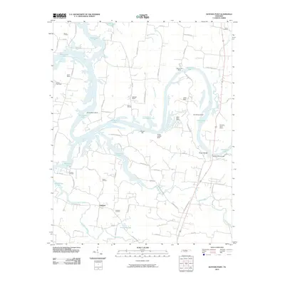
2010 Map of Hunters Point
USGS Topo · Published 2010About this map
Old Hickory Lake dominates the landscape north of Oakland, winding through a series of dramatic bends and bluffs in northern Wilson County. The waterway is defined by sharp geographical features like Indian Ladder Bluff and Sevenmile Bluff, alongside numerous islands such as Cunningham Island and Armstrong Island. This 2010 survey reflects a region where traditional rural life intersects with modern lakeside recreation, evidenced by the presence of Misty Cove Marina and Wilson Boat Dock. Genealogists will find significant value in the documentation of several family and community burial grounds, including Ebeneezer Cemetery, Belotes Cemetery, and Watson Cemetery. The road network, including Coles Ferry Pike and Belotes Ferry Rd, preserves the names of historic river crossings that once served this portion of the Cumberland River valley.
Find a feature on this map
69 named features on this map. Tap any name to fly to it.
Don’t see what you’re looking for? This feature index may not catch every label — zoom into the map to look around manually.
Map Details
Editions of this 2010 Hunters Point Map
This is the sole edition of this map. No revisions or reprints were ever made.
Other maps of this area

1942 · Statesville
USGS Topo · 1:100,000

1942 · Gallatin
USGS Topo · 1:100,000

1942 · Lebanon
USGS Topo · 1:100,000

1951 · Lebanon
USGS Topo · 1:24,000

1951 · Martha
USGS Topo · 1:24,000

1955 · Bethpage
USGS Topo · 1:24,000

1955 · Laguardo
USGS Topo · 1:24,000

1955 · Hunters Point
USGS Topo · 1:24,000

1955 · Gallatin
USGS Topo · 1:24,000

1956 · Nashville
USGS Topo · 1:250,000