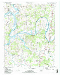
1994 Map of Hunters Point
USGS Topo · Published 1997About this map
The Cumberland River carves a deep, winding path through Wilson, Sumner, and Trousdale counties, defining the landscape via sharp oxbows like Belotes Bend and Cairo Bend. By the mid-1990s, the impoundment of Old Hickory Lake had transformed these waterways into a complex system of backwaters and inlets, submerged shorelines, and prominent features like Cunningham Island. Along the northern banks, Bledsoe Creek State Park preserves the riverfront near the historic settlement of Cairo, where several cemeteries and the Cairo Ch mark long-standing community roots.
Find a feature on this map
43 named features on this map. Tap any name to fly to it.
Don’t see what you’re looking for? This feature index may not catch every label — zoom into the map to look around manually.
Map Details
Editions of this 1994 Hunters Point Map
This is the sole edition of this map. No revisions or reprints were ever made.
Other maps of this area

1942 · Statesville
USGS Topo · 1:100,000

1942 · Gallatin
USGS Topo · 1:100,000

1942 · Lebanon
USGS Topo · 1:100,000

1951 · Lebanon
USGS Topo · 1:24,000

1951 · Martha
USGS Topo · 1:24,000

1955 · Bethpage
USGS Topo · 1:24,000

1955 · Laguardo
USGS Topo · 1:24,000

1955 · Hunters Point
USGS Topo · 1:24,000

1955 · Gallatin
USGS Topo · 1:24,000

1956 · Nashville
USGS Topo · 1:250,000