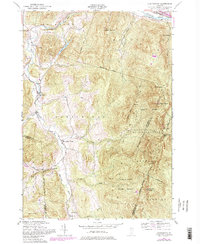
1948 Map of Huntington
USGS Topo · Published 1981About this map
Camels Hump State Forest dominates the eastern half of this landscape, centered on the unmistakable peak of Camels Hump and its northern shoulder, Camels Hump (The Lion). The famed Long Trail traverses the ridgeline, passing through high-altitude shelters such as Gorham Lodge, Montclair Glen Camp, and Wiley Lodge. This 1948 survey, with later photorevisions, captures a period when the valley economy of the Huntington River supported small clusters of settlement at Huntington, Huntington Center, and Hanksville. To the north, the Winooski River corridor serves as a vital transportation artery, carrying the tracks of the Central Vermont railroad. Local landmarks like Gillett Pond and the Airway Beacon on Robbins Mountain provide a glimpse into the regional infrastructure and geography of the Green Mountains at mid-century. Genealogists can trace rural life through sites like School No 12 and several local cemeteries.
Find a feature on this map
43 named features on this map. Tap any name to fly to it.
Don’t see what you’re looking for? This feature index may not catch every label — zoom into the map to look around manually.
Map Details
Editions of this 1948 Huntington Map
4 editions found
Other maps of this area

1903 · Middlebury
USGS Topo · 1:62,500

1905 · Middlebury
USGS Topo · 1:62,500

1906 · Burlington
USGS Topo · 1:62,500

1919 · Burlington
USGS Topo · 1:62,500

1919 · Lincoln Mountain
USGS Topo · 1:62,500

1920 · Lincoln Mountain
USGS Topo · 1:48,000

1920 · Middlebury
USGS Topo · 1:62,500

1921 · Richmond
USGS Topo · 1:48,000

1921 · Lincoln Mountain
USGS Topo · 1:62,500

1924 · Camels Hump
USGS Topo · 1:62,500