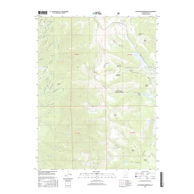
2017 Map of Huntington Reservoir
USGS Topo · Published 2017About this map
Huntington Reservoir and a series of smaller highland catchments sit high upon the Wasatch Plateau, marking a landscape defined by water management within the Manti-LaSal National Forest. This 2017 study illustrates the complex drainage network of the high country, where the Left Fork Huntington Cr and Miller Flat Cr feed into reservoirs like Miller Flat Reservoir and Rolfson Reservoir. The western portion of the map reveals a concentrated residential or resort-style development near the plateau's edge, characterized by a dense network of private roads such as Mountain Spring Dr and Deer Valley Dr. This contrast between the structured forest lands and the clustered mountain housing provides a clear view of modern land use in Sanpete County. Geographic landmarks like Towhead and Pritchett Flat serve as orientation points for the numerous canyons, including Seeley Canyon and Staker Canyon, that carve through the plateau.
Find a feature on this map
79 named features on this map. Tap any name to fly to it.
Don’t see what you’re looking for? This feature index may not catch every label — zoom into the map to look around manually.
Map Details
Editions of this 2017 Huntington Reservoir Map
This is the sole edition of this map. No revisions or reprints were ever made.
Other maps of this area

1885 · Manti
USGS Topo · 1:250,000

1895 · Manti
USGS Topo · 1:250,000

1923 · Scofield
USGS Topo · 1:62,500

1923 · Hiawatha
USGS Topo · 1:62,500

1925 · Scofield
USGS Topo · 1:62,500

1925 · Hiawatha
USGS Topo · 1:62,500

1956 · Price
USGS Topo · 1:250,000

1960 · Price
USGS Topo · 1:250,000

1962 · Price
USGS Topo · 1:250,000

1965 · Huntington Reservoir
USGS Topo · 1:24,000