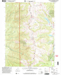
2001 Map of Huntington Reservoir
USGS Topo · Published 2004About this map
Manti-La Sal National Forest dominates this high-elevation landscape along the boundary of Sanpete and Emery counties. The geography is defined by a network of steep drainages, including Birch Creek, Eccles Canyon, and Bear Canyon, which feed into several high-altitude water bodies. Significant infrastructure for regional power and water management is visible, most notably the Lower Mt Pleasant Powerplant and Upper Mt Pleasant Powerplant situated along Pleasant Creek.
Find a feature on this map
30 named features on this map. Tap any name to fly to it.
Don’t see what you’re looking for? This feature index may not catch every label — zoom into the map to look around manually.
Map Details
Editions of this 2001 Huntington Reservoir Map
This is the sole edition of this map. No revisions or reprints were ever made.
Other maps of this area

1885 · Manti
USGS Topo · 1:250,000

1895 · Manti
USGS Topo · 1:250,000

1923 · Scofield
USGS Topo · 1:62,500

1923 · Hiawatha
USGS Topo · 1:62,500

1925 · Scofield
USGS Topo · 1:62,500

1925 · Hiawatha
USGS Topo · 1:62,500

1956 · Price
USGS Topo · 1:250,000

1960 · Price
USGS Topo · 1:250,000

1962 · Price
USGS Topo · 1:250,000

1965 · Huntington Reservoir
USGS Topo · 1:24,000