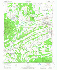
1948 Map of Huntington
USGS Topo · Published 1966About this map
Huntington and the surrounding Arkansas coalfields appear at a moment of heavy industrial activity following the Second World War. The landscape is defined by the legacy of resource extraction, with numerous Strip mines and specific operations like the Woodson Mine, Roy Smith Mine, and the Northwestern Coal Company dotting the terrain. The St Louis and San Francisco railroad provides the vital transit link for these mines, connecting the rail towns of Midland and Mansfield.
Find a feature on this map
55 named features on this map. Tap any name to fly to it.
Don’t see what you’re looking for? This feature index may not catch every label — zoom into the map to look around manually.
Map Details
Editions of this 1948 Huntington Map
3 editions found
Other maps of this area

1879 · Poteau Mountain
USGS Topo · 1:62,500

1887 · Poteau Mountain #1
USGS Topo · 1:62,500

1887 · Poteau Mountain #2
USGS Topo · 1:62,500

1887 · Greenwood
USGS Topo · 1:62,500

1890 · Fort Smith
USGS Topo · 1:125,000

1890 · Poteau Mountain
USGS Topo · 1:125,000

1899 · Poteau Mountain
USGS Topo · 1:125,000

1906 · Barber
USGS Topo · 1:62,500

1939 · Waldron
USGS Topo · 1:62,500

1940 · Waldron
USGS Topo · 1:62,500