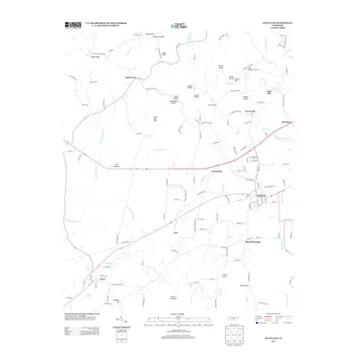
2013 Map of Huntland
USGS Topo · Published 2013About this map
Huntland serves as the primary hub in this southern Tennessee landscape, where the town layout is clearly defined by a grid of streets like Dogwood Dr and College Ave. The surrounding area is characterized by a series of hollows and ridges, such as Happy Ridge and Sulphur Hollow, reflecting the complex topography of Franklin County. Waterways like Beans Cr and Taylor Cr thread through the region, historically supporting local industry as evidenced by the locations of Falls Mill and Brown Mill. Small settlements and named locales like Old Salem, Elora, and Branchville are connected by a network of rural roads, including the descriptive Old Stage Rd and Stagecoach Dr, which hint at early transit corridors through the region. This 2013 survey documents the enduring rural character of the area, from the lowlands of The Barrens to the heights of Stovall Mountain.
Find a feature on this map
138 named features on this map. Tap any name to fly to it.
Don’t see what you’re looking for? This feature index may not catch every label — zoom into the map to look around manually.
Map Details
Editions of this 2013 Huntland Map
This is the sole edition of this map. No revisions or reprints were ever made.
Other maps of this area

1888 · Scottsboro
USGS Topo · 1:125,000

1892 · Scottsboro
USGS Topo · 1:125,000

1928 · Decherd
USGS Topo · 1:62,500

1936 · King Cove
USGS Topo · 1:24,000

1936 · Flintville
USGS Topo · 1:24,000

1936 · Beans Creek
USGS Topo · 1:24,000

1936 · Huntland
USGS Topo · 1:24,000

1936 · Belvidere
USGS Topo · 1:24,000
1936 · New Market
USGS Topo · 1:24,000

1936 · Mulberry
USGS Topo · 1:24,000