
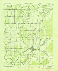
1936 Map of Huntland
USGS Topo · Published 1936About this map
The Nashville Chattanooga and St Louis Ry anchors the economy of this Franklin County landscape, linking the rail towns of Huntland and Elora. This mid-1930s survey reveals a deeply settled agricultural community where local industry is driven by water power, evidenced by the Stonewall Mill and Falls Mill along the network of creeks flowing from the Cumberland Plateau. The map documents a dense social infrastructure of country churches like Donaldson Grove Ch and schools such as Beans Creek Sch.
Find a feature on this map
68 named features on this map. Tap any name to fly to it.
Don’t see what you’re looking for? This feature index may not catch every label — zoom into the map to look around manually.
Map Details
Editions of this 1936 Huntland Map
This is the sole edition of this map. No revisions or reprints were ever made.
Other maps of this area

1888 · Scottsboro
USGS Topo · 1:125,000

1892 · Scottsboro
USGS Topo · 1:125,000

1928 · Decherd
USGS Topo · 1:62,500

1936 · King Cove
USGS Topo · 1:24,000

1936 · Flintville
USGS Topo · 1:24,000

1936 · Beans Creek
USGS Topo · 1:24,000

1936 · Belvidere
USGS Topo · 1:24,000
1936 · New Market
USGS Topo · 1:24,000

1936 · Mulberry
USGS Topo · 1:24,000

1936 · Lois
USGS Topo · 1:24,000