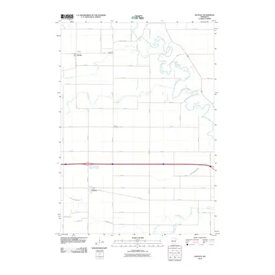
2010 Map of Huntley
USGS Topo · Published 2010About this map
The Blue Earth River meanders through the northeast corner of this agricultural landscape in Faribault County, where the small settlements of Huntley and Guckeen serve as focal points for the surrounding rural community. The map reveals a highly managed hydrological system designed for farming, characterized by numerous named waterways including Center Creek, South Creek, and drainage projects like Judicial Ditch Number Four and County Ditch Number Sixty. Local history is anchored by the Huntley Post Office and two burial grounds, West Verona Cemetery and Verona Cemetery, which offer valuable coordinates for genealogical research in this part of southern Minnesota. The terrain is crisscrossed by a rigid grid of township roads and county highways that emphasize the region's long-standing reliance on commercial agriculture and transportation.
Find a feature on this map
40 named features on this map. Tap any name to fly to it.
Don’t see what you’re looking for? This feature index may not catch every label — zoom into the map to look around manually.
Map Details
Editions of this 2010 Huntley Map
This is the sole edition of this map. No revisions or reprints were ever made.
Other maps of this area

1954 · Fairmont
USGS Topo · 1:250,000

1958 · Fairmont
USGS Topo · 1:250,000

1967 · Pilot Grove
USGS Topo · 1:24,000

1967 · East Chain
USGS Topo · 1:24,000

1967 · Truman SE
USGS Topo · 1:24,000

1967 · Winnebago
USGS Topo · 1:24,000

1967 · Elmore
USGS Topo · 1:24,000

1967 · Granada
USGS Topo · 1:24,000

1967 · Huntley
USGS Topo · 1:24,000
1967 · Delavan
USGS Topo · 1:24,000