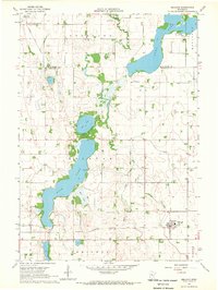
1967 Map of Delavan
USGS Topo · Published 1969About this map
Rice Lake and the long expanse of Lura Lake dominate this landscape on the border of Blue Earth and Faribault counties. The settlement of Delavan serves as the local hub, situated along the tracks of the Chicago Milwaukee St Paul and Pacific railroad in the southeastern corner of the quadrangle. This mid-century survey reflects a heavily managed agricultural environment, defined by a network of drainage infrastructure including Judicial Ditch No 49 and Judicial Ditch No 9, which funnel water through Rice Creek toward the larger basins. Genealogists will find several landmarks for family research, such as the Jackson Lake Cem near the northern shore of its namesake lake, the Rice Lake Cem, and local congregations at West Ch and East Ch. The map also details the local industrial footprint with a small Gravel Pit located near the northern township line.
Find a feature on this map
22 named features on this map. Tap any name to fly to it.
Don’t see what you’re looking for? This feature index may not catch every label — zoom into the map to look around manually.
Map Details
Editions of this 1967 Delavan Map
This is the sole edition of this map. No revisions or reprints were ever made.
Other maps of this area

1954 · Fairmont
USGS Topo · 1:250,000

1954 · Mason City
USGS Topo · 1:250,000

1955 · Bricelyn
USGS Topo · 1:62,500

1957 · Mason City
USGS Topo · 1:250,000

1958 · Mason City
USGS Topo · 1:250,000

1958 · Fairmont
USGS Topo · 1:250,000

1967 · Winnebago
USGS Topo · 1:24,000

1967 · Huntley
USGS Topo · 1:24,000
1967 · Amboy
USGS Topo · 1:24,000
1967 · Mapleton
USGS Topo · 1:24,000