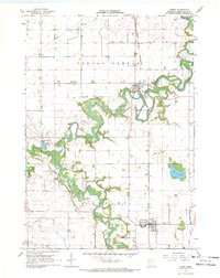
1967 Map of Amboy
USGS Topo · Published 1969About this map
The Blue Earth River meanders deeply through south-central Minnesota in this late-1960s survey, anchoring a landscape defined by its riparian bends and agricultural development. The settlement of Vernon Center sits near the river's northern reach, while Amboy serves as the southern hub, both connected by the Chicago and North Western rail line. Local history is well-documented through several burial grounds, including the Old Willow Creek Cem and St Mathews Cem.
Find a feature on this map
23 named features on this map. Tap any name to fly to it.
Don’t see what you’re looking for? This feature index may not catch every label — zoom into the map to look around manually.
Map Details
Editions of this 1967 Amboy Map
This is the sole edition of this map. No revisions or reprints were ever made.
Other maps of this area

1951 · Mankato West
USGS Topo · 1:62,500

1953 · New Ulm
USGS Topo · 1:250,000

1954 · Fairmont
USGS Topo · 1:250,000

1957 · New Ulm
USGS Topo · 1:250,000

1958 · New Ulm
USGS Topo · 1:250,000

1958 · Fairmont
USGS Topo · 1:250,000

1965 · Perth
USGS Topo · 1:24,000

1967 · New Ulm
USGS Topo · 1:250,000

1967 · Truman SE
USGS Topo · 1:24,000

1967 · Winnebago
USGS Topo · 1:24,000