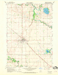
1967 Map of Mapleton
USGS Topo · Published 1969About this map
The Maple River and Cobb River converge in this agricultural landscape of southern Blue Earth County, framing the well-developed village of Mapleton. This late-1960s survey documents a region defined by its water management and rail connections, featuring extensive drainage systems like County Ditch No 35 and County Ditch No 16. The Chicago Milwaukee St Paul and Pacific railroad cuts a diagonal path through the township, serving as the primary transport artery for the local economy. Genealogists will find significant value in the documentation of several local burial sites, including Union Cem, Calvary Cem, and the Beauford Cem located near the northern bend of the river. From the shores of Perch Lake to the lowlands of Big Slough, the map illustrates a transition from natural glacial wetlands to an organized rural grid.
Find a feature on this map
19 named features on this map. Tap any name to fly to it.
Don’t see what you’re looking for? This feature index may not catch every label — zoom into the map to look around manually.
Map Details
Editions of this 1967 Mapleton Map
This is the sole edition of this map. No revisions or reprints were ever made.
Other maps of this area

1950 · Mankato East
USGS Topo · 1:62,500

1951 · Mankato East
USGS Topo · 1:62,500

1951 · Mankato West
USGS Topo · 1:62,500

1953 · Saint Paul
USGS Topo · 1:250,000

1953 · New Ulm
USGS Topo · 1:250,000

1954 · Fairmont
USGS Topo · 1:250,000

1954 · Mason City
USGS Topo · 1:250,000

1957 · New Ulm
USGS Topo · 1:250,000

1957 · Mason City
USGS Topo · 1:250,000

1958 · New Ulm
USGS Topo · 1:250,000