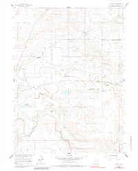
1960 Map of Huntley
USGS Topo · Published 1984About this map
Irrigation infrastructure and agricultural development define this portion of the Missouri River Basin during the mid-20th century. The landscape is heavily structured by the Springer Main Canal and an extensive network of drainage systems, most notably the Katzer Drain and its numerous lettered branches. These man-made watercourses support the small settlements of Huntley and Holly, reflecting the area's transition into a managed farming region. The Union Pacific railroad line, featuring the Pacific Siphon, cuts through the central terrain, anchoring the local transport network. To the south, the natural path of Horse Creek provides a contrast to the engineered geometry of the northern irrigation districts. Genealogists and local historians can locate smaller landmarks like the Hillview Home or the local Gravel Pit, which point to the rural residential and industrial character of Goshen County at the time.
Find a feature on this map
43 named features on this map. Tap any name to fly to it.
Don’t see what you’re looking for? This feature index may not catch every label — zoom into the map to look around manually.
Map Details
Editions of this 1960 Huntley Map
3 editions found
Other maps of this area

1896 · Patrick
USGS Topo · 1:125,000

1899 · Goshen Hole
USGS Topo · 1:125,000

1954 · Torrington
USGS Topo · 1:250,000

1954 · Cheyenne
USGS Topo · 1:250,000

1958 · Cheyenne
USGS Topo · 1:250,000

1958 · Torrington
USGS Topo · 1:250,000

1960 · Huntley
USGS Topo · 1:24,000

1960 · Hawk Springs
USGS Topo · 1:24,000

1960 · Lyman
USGS Topo · 1:24,000
1960 · Duroc
USGS Topo · 1:24,000