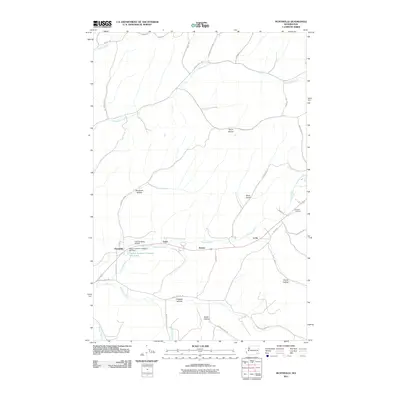
2011 Map of Huntsville
USGS Topo · Published 2011About this map
The Touchet River drainage in Columbia County serves as the central artery for this agricultural and industrial landscape near the start of the twenty-first century. Settlement patterns are concentrated along the river corridor, where the historic community of Huntsville and smaller locales like Varna, Dumas, and Long sit along the valley floor. A significant industrial landmark, the Dayton Lumber Company Mill Dam and its associated Dayton Lumber Company Mill Pond, points to the region's enduring reliance on timber and water resources.
Find a feature on this map
40 named features on this map. Tap any name to fly to it.
Don’t see what you’re looking for? This feature index may not catch every label — zoom into the map to look around manually.
Map Details
Editions of this 2011 Huntsville Map
This is the sole edition of this map. No revisions or reprints were ever made.
Other maps of this area

1919 · Walla Walla
USGS Topo · 1:125,000

1921 · Walla Walla
USGS Topo · 1:125,000

1937 · Pomeroy
USGS Topo · 1:96,000

1942 · Pomeroy
USGS Topo · 1:125,000

1953 · Walla Walla
USGS Topo · 1:250,000

1955 · Pullman
USGS Topo · 1:250,000

1958 · Pullman
USGS Topo · 1:250,000

1958 · Walla Walla
USGS Topo · 1:250,000

1966 · Dixie
USGS Topo · 1:24,000
1966 · Coppei
USGS Topo · 1:24,000